THAMES Valley Police is appealing for witnesses after a single vehicle fatal road traffic collision on the M40 between junctions 6 to 7 in the early hours of yesterday morning (Monday, 5/5).
Around 5.15am, a silver Vauxhall Astra was travelling northbound along the M40 motorway when it left the carriageway on the nearside, going through a fence and hedgerow into the field behind. The driver, a 29-year-old man, was pronounced dead at the scene.
Anyone who witnessed the collision or with information that may assist the investigation, should contact PC Adrian White of the Thames Valley Police Collision Investigation Unit at Aylesbury on the non-emergency number 101.
If you don’t want to speak directly to the police you can contact the independent charity Crimestoppers anonymously on 0800 555 111 or online at crimestoppers-uk.org.No personal details are taken, information is not traced or recorded and you will not go to court.
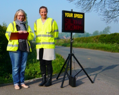
VILLAGERS frustrated by traffic speeding through their village, have decided to take matters in hand. Working in close liaison with their Police Community Support Officer, Jacky Madden, the village have rallied round to volunteer their support for the deployment of a SID (Speed Indication Device).
Elaine Cooke and Rachel Blake checking the speed of vehicles passing through Sydenham
With Thame Park Road into Thame currently closed for repairs, the villagers were concerned that Sydenham was likely to become even more of a ‘rat-run’ than normal and so have established a team of volunteers to monitor speeds during key periods. As part of an on-going operation the Parish Council is hoping that this will encourage drivers to be more aware of their speed and of the potential impact that speeding can have on our roads.
Paul Stancliffe, Chair of Sydenham Parish Council, said: “We all know speeding generally is an issue. However here in Sydenham we were keen to explore ways to address the issue directly within our village. Building on the speeding signs created by local children last year, we are always constantly looking at ways to tackle the speeding problem in our rural community.”
As a result of the villagers’ concerns, further activities, including the on-going deployment of the SID on approaches to the village, are planned.
MOTORISTS are being advised of a road closure for resurfacing work on the B4012 Thame Park Road which is due to start on Tuesday, April 22.
£400,000 will be spent to improve road safety and resurface the road, taking place at five specific locations which engineers have judged to be priority sites along the B4012. The work is expected to be completed by Friday, May 16.
The work will be carried out under a road closure for the full duration with a signed diversion in place. During the works access for residents to their properties (people who live in the area of road closure) will be generally possible, although there may be some instances where this may take longer than usual due to the progress of the construction and the need to control traffic within the closure.
Junction works at the Wenman Road and B4012 junction will start on April 14 and are expected to last for four days. These works will be carried out using four-way temporary traffic signals and this particular phase of work will not involve a closure.
County Councillor David Nimmo Smith, Cabinet member for highways, said: “The work we are going to do means that the road should not need any more repairs for some time, and I hope that everyone who will experience inconvenience will ultimately see the long term benefits.
“We have made sure that local people know about the works and how they can access their properties and will do all we can to get the work done as soon as possible.”
THAME bypass is currently closed (17.15 hrs) due to serious accident near Travelodge end, coming towards Thame from Oxford. …. Emergency services on scene. Diversion through Thame Town centre. A witness described seeing what she thought was a blue Ford Fiesta, a red VW Beetle and a second blue car.
BELL LANE, Thame – Scheduled Road Works – DELAYED Oxfordshire County Council will be closing Bell Lane to westbound traffic only and issuing a ‘No Waiting’ restriction in order to facilitate kerb drainage and repair works on a delayed date of Monday, March 24, for five days. Access will be maintained for emergency service vehicles and also limited access for those residents within the closure area, subject to the progress of the works. Please note that access routes will depend on exactlywhere the works vehicles are at any time and may need to be negotiated with the gang on site as necessary. For further information regarding the works please call OCC Highway and Transport on 0845 310 11 11.
THAME PARK ROAD Scheduled Road Works – Resurfacing and junction improvement works on the B4012 Thame Park Road are scheduled to commence mid-March and are expected to last a total of five weeks. For the first week, traffic on Thame Park Road will be managed with traffic lights and for the remainder or the works a diversion sign route will operate.
BELL LANE Scheduled Road Works Bell Lane, Thame, will be closed to westbound traffic only with a ‘No Waiting’ restriction for kerb drainage and repair works, on Monday, March 17, for five days. Access will be maintained for emergency service vehicles and also limited access for those residents within the closure area, subject to the progress of the works. Please note that access routes will depend on exactly where the works vehicles are at any time and may need to be negotiated with the gang on site as necessary. For further information regarding the works please call OCC Highway and Transport on 0845 310 11 11.
UPDATE 15/02/14 – 16:00 hrs – Power restored to Aston Rowant, Lewknor and parts of Chinnor and Watlington by 4.30pm today, area after 16 hours.
UPDATE 23:24 hrs – CHINNOR to ‘RISBOROUGH is badly flooded 2 ft and rising under bridge, there is also a tree blocking station road in chinnor. (from @aqualimeblue – twitter)
UPDATE 23:25 hrs – Tree down on Risborough rail line – passenger stranded. (via @aqualimeblue on twitter)
UPDATE 23:15 hrs – Careful if you are travelling from Thame to Chinnor, the road is badly flooded from Emmington to the Towersey triangle, trees down too. (via @BrownsThame – twitter)
UPDATE 20:37 hrs – Lower HADDENHAM to Aylesbury road closed at Ford crossroads – huge tree down – all routes blocked. Police etc on scene – via steve trenchard @oakfloorboy – twitter
UPDATE: 20:00 hrs – Thame United First team match scheduled for tomorrow at the ASM Stadium against Brimscombe has been postponed due to a waterlogged pitch.
UPDATE 20:00 hrs – DINTON crossroad closed as a tree just fell on a car, everyone OK (via @C_ASHTONCRISP); Power out at ASTON ROWANT (via @ccoateschef – twitter)
UPDATE 19:40 hrs – Tree down in Sydenham – cannot access from Kingston Blout end (via @redbarrington twitter)
UPDATE 17:00 hrs – B4009 at Watlington towards Shirburn – cable hanging in centre of the road…tree hanging there now – via BBC Travel twitter feed
UPDATE 15:00 hrs – B4009 at Crowell no longer closed and buses running through again (Arriva 40). But the road through the village of North Weston to Shabbington IS closed once again.
UPDATE 12.37 hrs – Only road closure remain in our area is the B4009 at CROWELL – via Oxfordshire County Council
UPDATE 12:00 hrs – Thame to Chinnor road has flooding as normal by Towersey triangle, only surface water on remainder at the moment. via @ThameLoyalty twitter
UPDATE today 14/02/14 -11.00 hrs – THAME to CHINNOR road – no deep water but the POTHOLES are getting worse & hidden by surface water so you need to drive slowly & carefully. (via @ims_mortgages on twitter)
UPDATE 11.00 hrs – Arriva service 40 bus currently unable to serve Chinnor. Going to Thame via Postcombe. Not serving Aston Rowant or Kingston Blount either. Red Rose service 275 also diverted but website out of date. (via twitter @BusUsersOxford )
UPDATE today 13/02/14 – 08.00 hrs – The only road currently closed in our area remains B4009 between Aston Rowant and Kinston Blount (also at Crowell )
UPDATE today 17.15 hrs – The road at Crowell is flooded & closed. “Worse than last time.” – Update from @tinalodge via twitter
UPDATE today 17.30pm – Standing water on Chinnor Road from Thame though passable. Tree down earlier this PM near Inn at Emmington but it has been cleared.
UPDATE today 12/02/14 – 09.00 hrs- Only official road closure this morning in our area is the B4009 between Aston Rowant and Kinston Blount (also at Crowell )
UPDATE 16.00 hrs – Road still officially closed – B4009 between Aston Rowant and Kinston Blount (also at Crowell ) – from Oxfordshire County Council website
UPDATE 14.00 hrs – Crowell and Kingston Blount were passable again today via @mybigmouth79 on twitter.
UPDATE today, 11/02/14 10.00 hrs – Arriva Service 40 covering Aston Rowant, Kingston Blount Chinnor and Kingston Stert is now running a normal service.
UPDATE 15.00 hrs – B4009 Lower Icknield Way in Chinnor closed around the Elderdene junction, because of flooding. Also B4009 High Street Kingston Blount, now closed both ways at Stert Road in both directions around the Stert Road junction, because of flooding.
UPDATE 12.05 hrs – B4009 High Street in KINGSTON BLOUNT around the Stert Road junction was passable with care at 08:50 this morning – message from Andy Henderson; Road through the village of North Weston near Postcombe still closed.
UPDATE 11.30 hrs today – CHANGES TO BUS ROUTES: Due to flood water, Arriva Service 40 is unable to serve Aston Rowant, Kingston Blount Chinnor and Kingston Stert instead running via Postcombe direct into Thame.
UPDATE 11.15 hrs today- The road from B4445 to Sydenham is now open. REMAINING CLOSED – B4009 between Aston Rowant and Kinston Blount (also at Crowell ); Lower Icknield Road, Chinnor
UPDATE 08.50 hrs today – Thame – Chinnor road passable just watch the potholes! From Steve Bailey via twitter
UPDATE 07.30am – 10/02/14 – B4009 Oxfordshire – B4009 High Street in KINGSTON BLOUNT closed in both directions around the Stert Road junction, because of flooding; Road from SYDENHAM to EMMINGTON in Emmington closed at the B4445 junction, because of flooding.
UPDATE 14.30 hrs – 08/02/14 – Lower icknield Way, CHINNOR, just about passable; Thame Road OK now but was bad yesterday morning- the ditches were overflowing – update from @woxwhite via twitter; PRIEST END flooded (see pictures HERE); The THAME to Chinnor Road is much better today – still got potholes! – update from lotte Duncan via twitter; REPORTS of houses flooded in Towersey yesterday, including the Old Dairy and houses near by – Towersey to Chinnor Road now clear; MORE gardens under water in Aylesbury Road, Thame, this morning (see pictures HERE)
UPDATE 08/02/14 – 09.00 hrs – Flood water on the Aylesbury Road, Thame, taken just before 8am this morning; via Kirsten Purnell on twitter. Other road closures – Mill Road, Shabbington, Stranbridge Road, Haddenham and Ickford Road, Sheldon Road, Worminghall Road – Ickford. Water creeping ominously close to houses in gardens in Aylesbury Road. SEE flickr pictures update.
UPDATE 23.00 hrs – Road through the village of South Weston near Postcombe closed due to flooding;
UPDATE 21.00 hrs – Lower Icknield Road, Chinnor, closed due to flooding.
UPDATE 17.45 hrs – The only road out of Worminghall not affected by floods is the road to Oakley (via twitter) – FLOOD alerts for the River Thame HERE
UPDATE 16.20 hrs – Severe flooding on Thame to Chinnor road has subsided. Still flooded Towersey triangle and beyond towards Chinnor, drive slowly!
UPDATE 15.00 hrs – Road closed between Northend and Shabbington – Not passable though some trying & having to turn back ! & very bad flooding all the way to Waterperry.
UPDATE 14.28 HRS – Cuttlebrook this afternoon – wide flooding & bridges & paths all impassable.
UPDATE 13.24 hrs – Sydenham Road into Thame from B4445 at Emmington is closed – IMAGES from those affected by the floods HERE
UPDATE 13.00 hrs – ROAD CLOSURES – B4009 between Aston Rowant and Kinston Blount (also at Crowell ); Sydenham Road into village from B4445 at Emmington
The Haddenham to Kingsey Road at the bridge, earlier this morning. Image courtesy of Mark Collins
UPDATES today, 07/02/14 – LOTS of problems this morning 9.00 am – Chinnor to Thame road severely flooded all the way from the Inn at Emmington to Thame. Very deep in places & still rising – avoid. River Thame at Cuddington now flowing over the road at Winchendon turn, but still passable. Roads to Thame, PrincesRisborough, Crowell and AstonRowant all pretty much blocked from Chinnor. (Message via twitter);
“Thame to Milton flooded – vehicles moving to avoid water ending up pretty much head on on a sharp bend.” BBC Travels says road between Thame and M40 only passable in one direction; Road between kingston blount and M40 junction 6 flooded standing water . Avoid – go via Thame or kingston Hill, Stokenchurch. Pegasus Way to Haddenham & Thame Parkway is flooded and almost impassible! Chinnor Road in Towersey is flooded! Can just about drive through slowly; Lot of water on the A4129 Longwick to Thame Road but ok to drive if carefully.
UPDATE 14.30 hrs today – The water level has gone down considerably at Cuttlebrook Nature Reserve in Thame, and IMS Morthages reported on twitter that most of the paths are passable now.
UPDATE 09.00 hrs today, 06/02/14 – The Thame to Chinnor road is passable as the water level has gone down considerably but drive with care as the road surface is very badly eroded with several large potholes.
UPDATE 23.50 hrs – From Chinno Railway – Things a little improved driving back about 22.30, still a big but passable flood on B4009 at Bucks/Oxon border.
UPDATE 20.15 hrs – THERE are several patches of standing/flowing water on B4009: M40 to Bledlow via Chinnor. Passable with care according to twitter follower.
FOLLOWING heavy, continuous rain and high winds overnight and today, flooding has once again returned to some of the local roads.
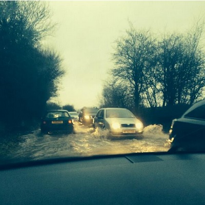
The Thame to Chinnor Road is once more ‘like a river’ according to local drivers on twitter today, concealing some very large potholes beneath, and again, the villages of Sydenham, so often the victim of flooding, is very badly flooded. The residents are once again asking that drivers avoid the village if they can, and if not, to drive very slowly through the water as the wash from cars driving too fast takes even more water out to their properties.
Sandy Lane in Tiddington though, which was closed for several days because of flooding, was re-opened earlier today. Dog walkers at Cuttlebrook Nature Reserve have reported that the brook has burst it banks and that the paths are all flooded and the bridge is not passable.
OXFORDSHIRE County Council will be carrying out carriageway resurfacing works and junction improvements on the B4012 Thame Park Road. The works are scheduled to commence mid-March 2014 and are expected to last a total of five weeks.
Road works planned for Thame Park Road
The road will be under traffic light regulation for the first week and then a diversion route will be in place for the remainder of the works. For more information call 0845 310 1111.
WITH the recent heavy rainfall in the area and more predicted over the coming days, Thames Valley Police is warning drivers to take extra care on the roads. Many local roads are already flooded and this is likely to get worse if the weather forecasts are correct for the coming days.
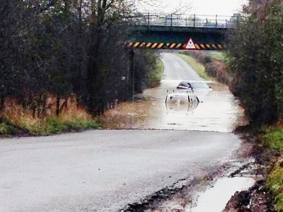
Several motorists have already been caught out trying to drive through floods – only to find that they are much deeper than they initially appear, leaving them (and their vehicles) stranded. The advice is:
Please do not ignore ‘Road Closed’ signs – they are there to keep motorists safe. Much more information and advice HERE and HERE to; (Useful if a flood should occur)
Local radio stations put out regular traffic updates, so please listen in to find out up to date information on flooding and traffic conditions and for Thame related incidents, HERE
Thame’s own firecrews have been extremely busy today. Watch Manager, Andy Ford, told Thame.Net: “Thame Fire fighters have had a busy day responding to flood related incidents, rescuing drivers from cars stuck in floods, assisting residents in Postcombe and Chalgrove in pumping out and diverting water that had flooded their houses.
“The Fire and Rescue Service has been very busy dealing with flood related incidents including rescuing drivers who have tried to drive through floods and got stuck. Please take note of Thames Valley Police’s guidance not to attempt to drive through Flooded roads and take note of Road closed signs. The depth of flood water is unpredictable and even those in large 4 x 4’s end up causing a wave which can wash into adjacent houses or damage other cars on the road. With more rain forecaste allow extra time for your journeys and be prepared for large puddles and floods in unexpected places.”
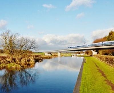
HS2 (‘High Speed Two’), is a railway line which will go from London to Birmingham in its first phase. It is planned to be followed by a second and third phase, connecting the Midlands to the northern towns of Leeds and Manchester, and then to Newcastle and Edinburgh. The line is designed to cover long distances at a high speed with few stops, using modern high speed trains, similar to the ‘Eurostar’ or Japanese ‘bullet trains’.
Artist’s impression of an HS2 train travelling across a river on a viaduct
So?
According to the official HS2 website, it will “revolutionise our railways, create thousands of jobs, bring major cities closer together, generate investment in neglected areas and provide passengers with an unprecedented travel experience”. It goes on to assert that an entirely new line is needed to provide greater and more efficient connectivity between the two largest cities in the UK. Anticipating further increased demand for Britain’s railways in the future, HS2 is also designed to reduce overcrowding on existing lines, which it is thought will improve local services and freight routes.
But…
There has, however, been extensive criticism of the HS2 proposals too, coming from across society. Many have accused numerous aspects of the HS2 case of being misleading. The ‘Stop HS2’ and ‘HS2 Action Alliance’ campaign groups have been particularly vocal in their opposition to the planned railway. There has also been opposition from across the political spectrum, despite the official support of all three main political parties to HS2. In addition to funding concerns, the Department for Transport has been accused of inflating the number of potential job creations, downplaying the environmental costs and ignoring alternatives and upgrades which could utilise infrastructure already in place.
How could it affect us?
Despite the massive coverage of HS2 there has been relatively little discussion of how it could affect Thame and the surrounding area. Thame is less than 10 miles from the planned route of HS2, as can be seen here. This has the potential to affect Thame and the surrounding area in a number of ways.
Environment
One of the most noticeable consequences of HS2 would be its effect as it crossed the Chilterns, cutting through the local Area of Outstanding Natural Beauty (AONB). This is currently a popular recreation and leisure destination for locals and visitors alike.
The Chilterns AONB Conservation Board has been particularly keen on drawing attention to the consequences that HS2 and its construction could have. The most obvious effect, from the Board’s and its supporters’ point of view is the track ‘scarring’ the landscape, and the noise pollution caused by the construction and trains.
As well as the construction of the track itself, HS2 will also involve the building of viaducts, tunnels, embankments and cuttings in, what is a protected AONB. These would be visible from local nature spots such as Coombe Hill, as well as the surrounding towns and countryside. Chiltern AONB believes that at least 3.79 miles of HS2 infrastructure will be visible within the protected area, contrary to HS2 Limited’s prediction of 1.5 miles.
It is estimated that the construction process would also cause nearly a million square metres of waste spoil. In addition, ancient trees and hedgerows are currently situated directly on the planned route. A number of rights of way, including The Ridgeway, The Icknield Way and the Chilterns Cycleway, would need to be intersected. In all, 13 Rights of Way, along with 13 roads, would need to be crossed by the route within the AONB.
History and Archaeology
As well as being naturally rich, the AONB area is also of historical and heritage value. HS2 will pass through an area scattered with listed buildings, medieval settlements and even Roman artefacts.
Particularly hard hit will be the remains of St. Mary’s Church and graveyard at the old village of Stoke Mandeville. This site would be “totally obliterated” by HS2 itself, and the construction of maintenance sidings directly on the site, according to the Buckinghamshire Archaeological Society (BAS). The BAS estimates that there may have been up to 3,900 human burials at the site over 650 years.
Flooding
As HS2 passes between Stone and Aylesbury, it will pass through an area at risk of flooding. HS2 has accommodated for this by planning two viaducts to carry trains over the floodplains just outside the town.
The Chiltern District Council’s Buckinghamshire Mitigation Blueprint for HS2 suggests that there is a chance that this construction could negatively affect the behaviour of flood water, potentially putting the western edge of Aylesbury at increased risk of flooding. Campaign group ‘Stop HS2’ go further, claiming that “a project with the landtake of HS2 will severely impact the potential for flooding, not just along the line but downstream on every river and watercourse affected”. The River Thame also intersects with the HS2 route.
The effect of construction and traffic on Thame
The Chiltern District Council has “significant concerns” about HS2’s impact on the safety and access of local traffic and transport during the construction period. For Aylesbury, it is thought that the consequences will be “severe”. The main route from Thame to Aylesbury, the A418, is likely to suffer diversions as HS2 is planned to go directly over it. This could affect commuters, shoppers and public transport links to Thame for an unknown period of time. It is feared that a number of lorries supporting the construction would cause damage and major disruption to local roads, especially as there are a limited number capable of supporting heavy vehicles. The number of vehicles that will used by HS2 staff are also considered a risk to the local road system.
Although HS2 is designed to benefit the whole country, its effects are likely be strongly felt in the Thame area, particularly in relation to traffic and the environment. It remains to be seen whether the disruption it would cause, would eventually be worth the national advantages that HS2 is projected to bring by its advocates, in the long term.
 Around 5.15am, a silver Vauxhall Astra was travelling northbound along the M40 motorway when it left the carriageway on the nearside, going through a fence and hedgerow into the field behind. The driver, a 29-year-old man, was pronounced dead at the scene.